
Key Takeaways
- DJI Matrice 30 and Matrice 4T lead enterprise SAR operations with advanced thermal imaging and AI capabilities
- Autel Robotics Max EVO 4T offers dual thermal sensors and extended flight time for comprehensive search missions
- Wingtra WingtraRay provides VTOL capabilities with fixed-wing endurance for large-area coverage
- Modern SAR drones feature autonomous flight modes, real-time data transmission, and weather-resistant designs
- AI-powered human detection and thermal imaging significantly improve rescue success rates in challenging conditions
Introduction to Search and Rescue UAVs
At Covered 6, we recognize the transformative impact unmanned aerial vehicles have on search and rescue operations. These advanced platforms have redefined how emergency response teams execute critical missions, delivering capabilities that enhance operational effectiveness while minimizing risk to personnel. The progression from basic aerial surveillance to AI-driven autonomous systems marks a significant evolution in public safety technology—a shift we actively support through our partnerships and solutions.
Modern search and rescue drones empower emergency responders with unparalleled situational awareness, enabling rapid location of missing persons across vast and challenging terrain. These professional-grade systems integrate seamlessly with existing emergency response frameworks, providing real-time aerial data to rescue teams and accelerating decision-making during critical incidents.
The role of drone technology in saving lives during emergency operations is indispensable. From dense forests to disaster zones, unmanned aerial vehicles serve as essential assets for SAR teams worldwide. Covered 6 is proud to collaborate with industry leaders to deliver these cutting-edge technologies, ensuring our partners maintain the highest standards of operational readiness and mission success.
Best Search and Rescue Drones in 2025
Below is a detailed comparison of the leading search and rescue UAVs currently utilized in professional emergency response contexts:
Model | Flight Time | Range | Thermal Camera | Weather Rating | Price Range |
|---|---|---|---|---|---|
45 minutes | 15km | 640×512 | IP55 | $10,000-$15,000 | |
45 minutes | 25km | 640×512 | IP55 | $15,000-$20,000 | |
42 minutes | 15km | Dual 640×512 | -20°C to 50°C | $8,000-$12,000 | |
59 minutes | 10km | Optional payload | Weather-resistant | $25,000-$35,000 |
These platforms deliver significant operational advantages for search and rescue teams, offering cost-effective alternatives to manned aircraft without compromising coverage or data quality.
DJI Matrice 30 – Professional Enterprise SAR Platform

The DJI Matrice 30 is a flagship solution for SAR missions, equipped with a sophisticated thermal and zoom camera system featuring 200x hybrid zoom. Its 45-minute flight endurance and IP55 weather rating enable reliable operations in adverse conditions such as rain, snow, and high winds.
Featuring an integrated RTK positioning system, the Matrice 30 provides precise geolocation capabilities crucial for directing search and rescue teams during rescue operations. AI-driven subject recognition and automated flight modes allow SAR teams to optimize mission planning while the drone executes search patterns autonomously. Coupled with real-time data transmission via DJI FlightHub 2, this platform delivers comprehensive situational awareness to command centers.
Covered 6 integrates such advanced SAR drones into public safety operations, ensuring emergency responders benefit from reliable thermal imaging that detects heat signatures through light vegetation and in low-light scenarios—capabilities vital for effective search and rescue efforts.
DJI Matrice 4T – Next-Generation AI-Enhanced SAR Drone
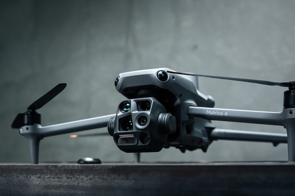
The DJI Matrice 4T represents the forefront of search and rescue drone technology, incorporating artificial intelligence for autonomous victim detection. Building on proven SAR capabilities, it offers enhanced dual-spectrum thermal imaging that improves detection accuracy in complex terrains.
With a 45-minute flight time supported by hot-swappable batteries, the Matrice 4T supports continuous mission operations. Its advanced obstacle avoidance technology facilitates safe navigation in mountainous and urban environments alike. Integration with emergency dispatch systems enables rapid deployment, minimizing response times.
AI algorithms distinguish human heat signatures from environmental sources, reducing false positives and allowing SAR teams to focus resources efficiently. Covered 6 actively supports the deployment of such AI-enhanced platforms to maximize the effectiveness of search and rescue efforts.
Autel Robotics Max EVO 4T – Dual Thermal SAR Specialist
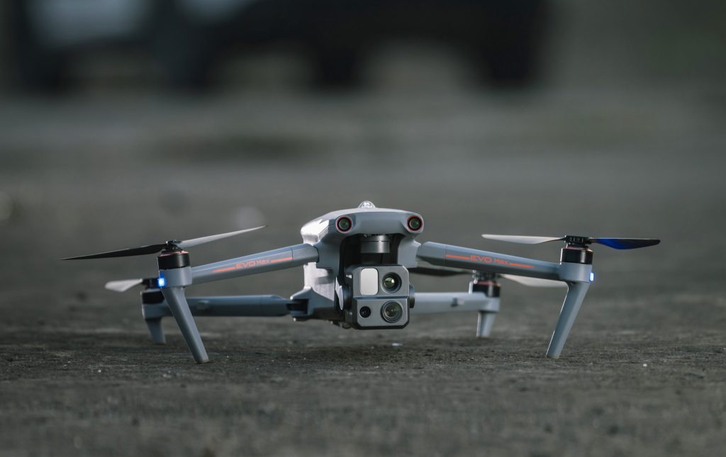
The Autel Robotics Max EVO 4T is a specialized SAR drone featuring dual 640×512 thermal sensors for superior heat detection. Its 42-minute flight endurance and intelligent battery management make it ideal for extended search operations in difficult terrain.
With a 15km transmission range, this platform supports beyond visual line of sight operations essential for remote or hazardous search areas. Rated for operation between -20°C and 50°C, it maintains performance across diverse climates.
Advanced gimbal stabilization ensures stable imaging in windy conditions, providing consistent thermal and visual data critical for emergency response teams. Covered 6 integrates such rugged platforms into public safety solutions to enhance operational reliability under demanding conditions.
WingtraRay – VTOL Long-Range SAR Solution

The WingtraRay combines vertical takeoff and landing (VTOL) capabilities with fixed-wing endurance, delivering up to 59 minutes of flight time and coverage of 350 square kilometers per mission. This hybrid design offers operational flexibility for extensive SAR missions.
Transitioning seamlessly from vertical takeoff to forward flight, it supports diverse search scenarios from wilderness to urban disaster response. High-resolution RGB and thermal payload options provide comprehensive imaging, while autonomous mission planning enables systematic coverage of large search areas.
Lightweight at 4.3kg, the WingtraRay allows rapid deployment by rescue teams. Covered 6 recommends this platform for operations requiring broad area surveillance where multiple drones might otherwise be necessary.
Essential SAR Drone Capabilities
Professional search and rescue UAVs require specific technological features that distinguish them from general commercial drones. Thermal imaging remains paramount, enabling detection of human heat signatures over considerable distances and through light vegetation, even in low visibility or nighttime conditions.
High-resolution optical cameras with powerful zoom complement thermal sensors, providing detailed visual confirmation and documentation. The integration of multiple cameras enhances the drone’s video feed quality, delivering critical aerial data to search and rescue teams and command centers.
Real-time situational awareness is achieved through live video streaming, GPS, and RTK positioning systems that offer precise victim location coordinates. Weather resistance is essential, ensuring operational continuity in rain, snow, wind, and temperature extremes common in SAR missions.
Covered 6’s expertise ensures that SAR teams are equipped with drones featuring these advanced capabilities, enabling effective search and rescue efforts in remote or hazardous areas.
Advanced Features for Search and Rescue Operations
Modern SAR drones incorporate artificial intelligence for human detection, minimizing false positives and optimizing the search process. Algorithms analyze thermal signatures, movement, and visual cues to differentiate humans from environmental heat sources or animals.
Automated flight patterns facilitate systematic area coverage, allowing rescue teams to concentrate on data analysis. Night vision and infrared capabilities extend operational windows to 24/7, critical for emergency response scenarios where every minute counts.
Emerging communication relay systems extend radio coverage for ground teams in remote locations. Some platforms also support delivery of emergency supplies, such as food and medical kits, directly to victims while ground teams mobilize.
Through our partnerships, Covered 6 integrates these advanced features into comprehensive public safety solutions, enhancing SAR efforts across diverse operational contexts.
SAR Drone Applications and Use Cases
Search and rescue UAVs are indispensable in wilderness operations, particularly in dense forests, mountains, and remote areas where traditional methods are slow and resource-intensive. Aerial thermal imaging enables rapid identification of potential victim locations, accelerating the search process.
Urban disaster response benefits from drones’ ability to assess structural integrity and locate trapped individuals without exposing responders to unnecessary risk. Flood monitoring and water rescue coordination leverage drone capabilities to identify stranded persons and plan safe rescue routes.
Avalanche victim location is a critical application where thermal imaging expedites discovery beneath snow layers. Maritime SAR operations utilize drones for coastal and offshore searches, with thermal detection aiding in locating persons in water during low-light conditions.
Covered 6 collaborates with emergency response teams to tailor drone deployments to these varied applications, ensuring mission success and enhanced public safety.
Technology Integration and Command Systems
Integration with existing emergency dispatch and CAD systems allows seamless inclusion of drone operations into established protocols. Real-time data sharing among multiple drones and ground teams creates a unified operational picture, critical for coordinated SAR efforts.
Cloud-based mission planning and post-flight analytics improve operational efficiency. Mobile command centers equipped with live video and mapping displays provide comprehensive oversight, enabling better resource allocation.
Frequently Asked Questions
What is the typical flight time for search and rescue drones?
Professional SAR drones typically offer 30-50 minutes of flight time, with models like the Wingtra WingtraRay reaching up to 59 minutes via hybrid VTOL and fixed-wing efficiency. Battery technology improvements continue to extend these capabilities.
How effective are thermal cameras for finding missing persons?
Thermal imaging detects human heat signatures from kilometers away, penetrating light vegetation and darkness. When combined with AI detection algorithms, thermal cameras significantly enhance rescue success rates by reducing false positives.
Can SAR drones operate in bad weather conditions?
Top-tier SAR drones feature IP55 weather ratings and operate reliably in rain, snow, and winds up to 15-17 m/s. Temperature operating ranges from -20°C to 50°C enable deployment in diverse climates, though extreme conditions may still pose operational limits.
What training is required to operate SAR drones?
Operators require Part 107 certification and SAR-specific training on software, thermal imaging interpretation, and emergency protocols. Training durations vary, with many agencies developing tailored programs to meet operational needs.
How do SAR drones communicate with search and rescue operations?
SAR drones use radio links, cellular networks, and satellite connections to transmit real-time video, GPS, and telemetry data to ground control and command centers. Redundant communication paths ensure data integrity even in challenging environments.
Covered 6 is committed to providing comprehensive training and support to maximize the effectiveness of SAR drone deployments in public safety missions.